
The Story
Coast to Coast Diary
Chapter 1 — Sea of Asphalt
The feeling is of being in the middle of the ocean even though the nearest beach is over 3,000 km away. A long strip of asphalt stretches toward the horizon and, in the most classic image of American immensity, ends in a single distant point. From one meter above the ground the whole horizon is visible; it feels like standing on a huge sphere. To our left the other lane runs more than 100 meters away. Long, heavy trucks pass us and, sometimes curious about the strange motorcycle and the unusual plate, greet us with a friendly wave.
Kilometers of fences with thousands of cows alternate with hours of perfectly straight road, unchanging and yet never boring. Around us a single prairie spreads out, grass and shrubs in green and brown. Darker patches appear in the distance: ranches whose access roads are often indistinguishable from cattle tracks and dry creek beds (wash).
Mailboxes line the freeway at intervals of dozens of kilometers and are often the only sign that somewhere there is a house and a ranch. Rows of mailboxes scorched by heat and rusted by the weather are sometimes a funny presence in places where you can’t even spot a power pole or any kind of building.
The passage from Arkansas to Texas is almost immediate, unlike other U.S. borders. No mountains or rivers divide the two states, and yet the transition to the West is clear and unmistakable. TV, films and magazines have shown us these places for years; now, crossing those legendary territories, flashes of déjà vu pass through our minds.
For years a key part of my memories will be the feeling of the solid handlebars of the Moto Guzzi 850‑T3 between my hands, Anna’s silent presence behind me, and the vibrating force of the V90 engine while 8,000 km of American land scroll beneath the front wheel—from New York to Los Angeles.
Chapter 2 — The Call of the Dream
It had always been one of my drawer‑dreams. As a teenager I would trace a hopeless route between the two coasts on a map of the United States. The coast‑to‑coast was a myth, one of those things that would be great to do “one day.” Route 66 was part of that dream too, part of the collective imagination. I dreamed of a long, empty two‑lane road vanishing into the horizon, passing deserted towns and car carcasses. I imagined myself in a car—just crossing that vast country was the adventure; the vehicle did not matter.
Then life changed. I married a woman who shares my dreams and passions, and one day Anna and I fell in love with a beautiful Moto Guzzi 850T3, former police. Love at first sight. From a used 125 Vespa as a teenager, at over 30 I moved to a much larger bike that demanded a different kind of commitment. Together we quickly became motorcycle travelers—and decent mechanics.
The spark came when we learned of a travel agency organizing a coast‑to‑coast “with your own bike.” Bingo! That phrase—“your own bike”—clicked. We knew we could do it ourselves; we were adults, fairly seasoned, and money could be found. What we lacked was the push. So eight months in advance I went all in on planning and research. A growing anxiety followed us for months, the fear that something would ruin it all.
Chapter 3 — Planning
Our independence (people often call us bears) led us to use only a few services from the agency: shipping the bike, customs paperwork, and U.S. insurance. We decided to do the entire trip alone. The plan was simple: arrive in NY, pick up the bikes, ride on our own, and after 23 days meet the “big group” in Los Angeles to ship the bike back home.
We set a few strategic rules: no motel reservations, no city visits, travel through the land. We wanted to be part of the country, to stay with the people, eat in their places, sleep in small towns, and—why not—have a bit of adventure with wisdom and prudence. That meant avoiding big cities and only roughly planning stages.
It was important to estimate distance and time to avoid being late and rushing everything, or arriving in California too early and skipping interesting inland areas. I bought Map&Route online. With it I created a rough route that balanced time with what there was to see. I kept a margin of about four days to use as a buffer for mechanical problems or delays, or simply to rest if we suddenly felt exhausted. Twenty‑three days sound like a lot; in reality they allow you not to sprint, but still not enough to see everything—especially when it comes to huge natural parks like the Grand Canyon, Monument Valley , Great Smoky Mountains, Arches, and more.
I really wanted to visit old Route 66, so I bought two books online to learn its fascinating history, where it runs, what to expect, and the most interesting places to visit. I’ve always been fascinated by abandoned towns, so I made a list of detours to reach famous ghost towns.
The commonly recommended “low route” mainly follows I‑40. The main stages were NY, Washington, a small detour to visit the Skyline Drive, I‑80 toward Oklahoma City where we would follow the old Route 66 when possible, then a detour north to Santa Fe. From there south again to rejoin I‑40/Route 66, then north to Utah (Monument Valley, Grand Canyon, Lake Powell, Zion , Bryce ). We would cross Death Valley and reach San Francisco, then follow the coastal US‑1 to Los Angeles.
A separate chapter is clothing and bike preparation. We packed many T‑shirts, three pairs of jeans, lots of socks, a wool sweater, a denim jacket and a rain jacket. We had two side bags, one rear bag, and a large tank bag. We also carried many maps, emergency tools, a camera, pen and paper. The bike was checked and serviced—no special preparation, just an “Italy” sticker next to a “USA” on the tail.
Knowing the risks (you can’t do 8,000 km in 20 days without breakdowns), I joined MTS, the Moto Guzzi USA club (MGNOC), and the American Motorcyclist Association (AMA). MTS offers towing to the nearest shop within 20 minutes anywhere in the U.S.; $35 for 60 days—excellent. MGNOC gave us an information network for breakdowns and, more playfully, a chance to meet fellow enthusiasts along the way. AMA offered motel discounts and basic roadside assistance. MTS was also partnered with AMA. All three offered 10–15% discounts on major motel chains.
We took only a few hundred dollars cash, which we even ended up keeping. For everything else, credit card.
The bike was shipped from Bergamo in a container one month in advance. It was held upright on an aluminum frame and tied down by four straps on the handlebars and rear suspension, keeping it firmly compressed. On the return, the method was simpler but effective: the bikes were stood up directly in the container, with straps anchored to the floor. We were very worried, but everything went fine.
The bike was recovered at a location near NY the day after we arrived. The engine turned hesitantly because the battery had weakened after 30 days in humidity, even though I had disconnected it. The starter relay only clicked briefly. I was about to ask for help when I opened the relay’s plastic cap and pushed the internal pin by hand. After a couple of empty turns, the engine roared with pride. Great bike! A disappointed silence around us. We were independent, we knew the bike, and we would make it—somehow. We loaded the bags at the hotel and, with a big knot in the heart, departed.
Chapter 4 — Route 66
How can you not mention the scale of that country? Wide multi‑lane roads and a broad‑breath landscape. We left Manhattan behind. The Empire State Building rose among the skyscrapers, and to our left we could glimpse Miss Liberty. We had been to the USA before and driven through some states, but the feeling now was different and intense. We felt at the center of attention, even though in big cities people have other things to think about than noticing two Italian riders. We both thought of the thousands of kilometers separating us from the West Coast, and of the unknowns, breakdowns, and the solid bike beneath us.
The weather was a bit gloomy for a couple of days. We crossed Philadelphia and Washington quickly.
This first stretch, up to I‑80, crosses the most industrial and dense part of the U.S. (excluding the Chicago‑Detroit area). Roads are toll roads (rare), and we passed toll booths much like we do at home. Two small notes: American cars “leak oil like crazy,” and when they stop they leave slick patches. At toll booths, we risked slipping. The oil mixed with A/C water makes the surface more slippery than pure ice. Add a layer of melted coins embedded in hot tar and you get a dangerous mosaic—sometimes even toll operators warn you.
Washington is not exactly glittering; the roads are rough and only the central area with Capitol Hill, the White House and the surrounding monuments is worth a short detour from the freeway. We crossed the Potomac and headed toward Fort… then took a side road to Skyline Drive on the advice of American motorcyclist friends. The internal roads are much nicer than long asphalt strips: you see towns, schools, farmers’ houses, railways and bucolic landscapes. A few hours away from the capital’s traffic we rode among high hills and woods. We quickly realized that back roads lengthen the travel time, and knowing the most fascinating things were further west, we rejoined I‑80 after refueling.
Gas stations deserve a note: regular gas no longer exists, only unleaded and diesel. But there are different octane ratings, from 88 to 94, depending on the area. Choose the highest octane you can find. If you have an old engine like ours, I recommend an additive for leaded engines to avoid knocking and help the valves. I know people with older bikes who never used it—your call. To refuel you either pay before or after, or at the pump with a card, but you always have to handle it yourself. Beware: not all pumps have an automatic stop, so you must watch the tank. We learned this at the first “dumb” pump when I flooded my pants and the engine smoked. No fire, thankfully. Since then I always keep an eye on the filler (even in Italy).
We continued toward Nashville. The landscape softened into hills and countryside through West Virginia, Tennessee and Arkansas. The farms, far apart, felt “already seen”: wooden buildings, sometimes red, with semi‑cylindrical shapes and rounded roofs (Twister, The Witness…). Near… we had a day of rain—actually 10 minutes of rain: violent but brief. The weather follows the geography; it changes quickly and decisively. If it rains, it pours; if the sun comes out, it’s sweltering. It’s interesting how you can foresee rain: the entire sky is visible, and you can see cloud formation in one direction. Riding for hours, you feel whether you are moving toward or away from it. You can even play with it by choosing a different route. You enter the shadow quickly, see the rain streaks beyond, stop to change, and a few minutes later it pours cold and hard (wool sweaters do their job). Thirty minutes later a bright sun forces you back into a T‑shirt.
We arrived in Nashville and, after choosing a motel, realized our watch was an hour behind… or all of their clocks were ahead. We were used to time changes only after flights; we forgot that here we would cross three time zones—this was the first, proof we had covered a lot of distance.
Bad surprise in the morning: after a few kilometers in the rain, a tire was flat. We left the freeway and parked behind a gas station. It was Sunday, no mechanics nearby, and I had no spare tube (you never think of everything). There was a motel nearby; we stopped. I called the MGNOC president (with whom I had exchanged emails) and he put me in touch with a member in Nashville. Soon an Italian manager of a large Nashville workshop called me and said a mechanic would be waiting Monday at 10 for a tube replacement. I needed to get the bike there, so I called MTS. They said a van would arrive at nine in front of the motel and we wouldn’t pay a dollar. Hooray! We took a “day off.” We were lucky to puncture between long stages; if it had happened mid‑stage we would have had more problems. This sense of dodged danger and a constant “sword of Damocles” followed us throughout the trip—especially in isolated areas (buying a spare tube… I hadn’t thought of it!).
At one of the many fuel stops we left the freeway and entered a small green forest for a few minutes. We found a station that served locals more than freeway traffic. Two shirtless blond kids with long hair stepped out of a metallic pickup. They wore cool cyclist‑style sunglasses and engine parts stuck out of the pickup bed. As we passed, they turned their heads to the bike and shouted, “which year?” I replied “seventy‑five.” They kept walking toward the shop with a thumbs‑up: “you’re cool man!” After a moment of mental alignment my wife and I smiled at this fun encounter. It was just one of many pleasant, quick meetings. Drivers, mechanics, clerks, waiters and motorcyclists often stopped to talk. The deeper we went inland, the more English slid into a comic “a wanna a ganna” accent. Truckers shouted things as they passed: “too hot now,” “watch the storm if you go west,” “motorcycles are cool but you pay when you stop,” “how is Gutzi doing?” and “where are you from, where are you going?”
We pushed through a very long stage to regain time. The longest stage of the trip: from Nashville to Forrest City, crossing the Mississippi. A big emotion hit us as we crossed the long bridge near Memphis. The river’s spans passed over the water for minutes. We passed under the sign “Mississippi River” and our mind went to Tom Sawyer. We crossed marshes for kilometers after the river, surrounded by firs and reeds, already fearing mosquitoes at our next stay.
The next day we headed to Oklahoma City; I couldn’t wait to take Route 66. The day was brutally hot; the sun hammered. It’s incredible how much shade helps you breathe. In such days we developed the habit of using sunscreen. We stopped at a Tourist Welcome Center to let the heat ease, and to look for lodging and plan where to sleep that evening.
We recommend stopping at Welcome Centers; they’re usually a few kilometers into each state. You can rest, drink, pick up maps or postcards. There are booklets with motel coupons (not combined with AMA/MTS/MGNOC discounts) but useful to find your preferred motel; after seven hours in the saddle you expect the motel like a mirage. It’s also unpleasant to ride with the sun in your face all afternoon and often I rode with one hand on the bars and the other on my helmet visor to avoid glare—like a novice Apache scanning the horizon. Around 6 p.m. the sun is very low and road signs and motel signs are hard to read.
Every morning we performed a small ritual: check the bike, levels and bolts. We carried three red one‑gallon jugs: distilled water, gearbox oil and engine oil. I checked tires, suspension, spark plugs and opened the air filter to clean it (just kidding!). We were ready and took Route 66 from the outskirts of Oklahoma City.
Even in a dense area, Route 66 immediately felt unique: strangely wide with a traffic flow out of proportion. Buildings along it weren’t new and shiny like the last 3,000 km had accustomed us; mostly workshops, small motels and old gas stations turned into souvenir shops. The road left the metropolis and headed west. It wasn’t as straight as I expected, instead it gently meandered through small towns. El Reno left a special memory: Route 66 snakes a couple of times through town like a main street. The specific Route 66 map I bought was invaluable, because officially the road has been removed from road atlases and is not easy to follow. Brick buildings, three stories high from early last century, line the street for a few hundred meters. Doors and windows are boarded up; few old cars pass through. After a few hundred meters low wooden houses appear, then everything vanishes into the wide countryside—like stepping decades back in time. We followed the rest of Route 66 with difficulty: it is crossed, overlapped, or swallowed by I‑40. Sometimes we traveled along the freeway; other times we crossed it above or below. For many kilometers we watched Route 66 run alongside I‑40. It often disappeared into grass as nature reclaimed it. We left I‑40 for the most interesting stretches: Hydro, Weatherford, Clinton, Elk City, Sayre, Eric, Texola, Shamrock. Just riding 66 instead of the fastest road made us feel like explorers. We refueled at old places with mechanical pumps; inside it felt like a tiny Greek village supermarket. People there were not overly friendly; no fake smiles, but more real. Sometimes the road breaks; in those stretches you see the remains of buildings and gas stations that in the 1920s and 30s had lines of cars and crowded parking lots.
Eric left a powerful memory. It lies several miles south of I‑40 and used to be active. Of its motels only signs or a collapsed shack remain. No movement, but the broad street is still maintained. Gas stations and workshops closed at different times and many cars seem abandoned. I recommend the book that tells the story of this road—a path of millions fleeing poverty and drought toward the California mirage, its mild climate and jobs. Some of the cars left here belonged to people who ran out of money for gas. Shamrock is also interesting, with a 1936 Art Deco building. It isn’t as abandoned as others, but if you pass here, be respectful and let the only trace of your passage be the sound of your motorcycle.
Chapter 5 — Toward the Great West
We had breakfast and after a couple of photos we left. We rode long western roads, crossed Gallup—an old Indian center now touristy, with all the souvenir kitsch you can imagine. The landscape kept changing. The dry Texan plain began to rise and we crossed into Arizona among red rock mountains that evoked Indians and cowboys. Red mountains alternated with desert and then other colors—nothing was monotonous despite hours on the same road. We made a short detour north to visit Santa Fe, a happy tourist island on a plateau above 2,000 meters. We met more Guzzi friends and left the next day.
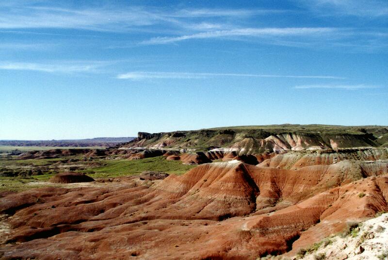
After crossing the Rio Grande and Rio Bravo we arrived at the Painted Desert & Petrified National Park. It was late but we decided the sunset hour would reveal the lunar landscape differently. We were fascinated by multicolored hills formed below the desert level around us. We still couldn’t believe how fast the scenery changed. Leaving the freeway, it vanished; entering the park (a red barrier along a thin asphalt road in the desert), the view opened into a small but long canyon beneath the surface. This was what we wanted from the trip: to be stunned by nature. We visited a field of petrified logs, the remains of a forest. Tired, we searched for a motel, had dinner, and crashed.
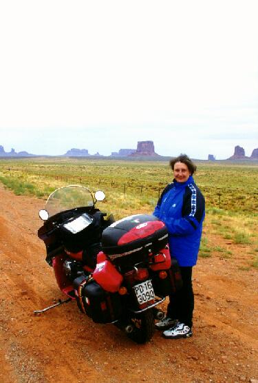
We left I‑40 for the last time and headed north: Utah. The weather was bad due to a tornado that had struck Salt Lake City. This detour worried me because we were leaving an important and busy artery to enter less‑traveled Indian lands, without freeways, without motel chains, without the certainty of a gas station or shelter. We entered the “deep west,” leaving safety behind. Billboards disappeared, replaced by small towns and warnings about wildlife. We zig‑zagged across a landscape like Wile E. Coyote. Few cars, no trucks; instead, Indian pickups passed with rifles on the rear window. Often we found ourselves riding inside a canyon that contained another canyon, its edges so far that they were often invisible. A bit of fog and we would have never known a drop was just a few hundred meters away. The cold became intense and we layered up. We arrived at Monument Valley in a persistent fine rain—an Indian said they hadn’t seen rain in August since 1920… maybe. Rain in the desert is rare in summer. The place is gorgeous but for our taste too crowded with tourists and big buses. We took a few photos and made a quick ride on the dirt around the sacred “monuments.” It was too dangerous for a road‑only T3 loaded with 400 kg; after three switchbacks we turned back. We left Monument Valley drinking in one of the most beautiful landscapes we’d ever seen. The rain went away as usual, leaving a partly clear sky. We rode slowly through that stunning land, stopping at every curve to savor it. At Mexican Hat , named after a rock formation, we met the Falcone group by chance; we dined with them in teepees, eating meat cooked over flames and piles of beans (“the John Wayne food,” said the sly Indian).
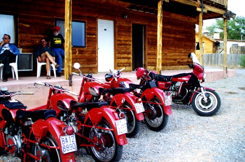
Sly indeed: supermarket meat and canned beans. He offered teepees for $45 a night (no heat or bathroom) while he and his wife slept in a brand‑new RV with satellite. It was fun. He moved from table to table telling improbable western stories; folkloric but not very real. He kept talking even when no one listened. The best moment was when I pulled out the map to show our route for the next day and ask about road conditions. An Indian with a real look leaned in, tapped his forehead and said, “I drew those maps, I have them all in here.” “I know many more that I didn’t tell the FBI.” It was hilarious. He continued, “they asked me to burn them, I said yes, but I kept several.” Nobody listened and he moved on to another table to repeat his tales.
Chapter 6 — Deserts, Canyons, Rain
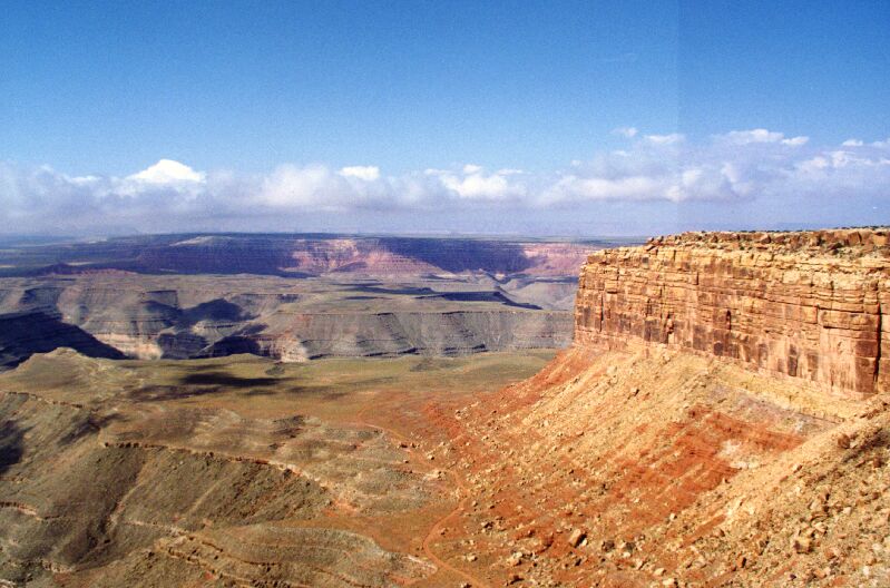
We left excited for another mythical point: Muley Point . It’s where Thelma and Louise drove off in the film’s dramatic finale. To reach it I did something crazy: first a winding dirt road climbing a canyon with no protection, then over 10 km of another dirt road, sometimes muddy, running along the canyon rim. We found 1,500 meters of drop beneath us. We sat in complete silence, staring at a valley more than 150 km wide. The weather granted a lucky pause in the rain. Then off again toward the Grand Canyon.
Along the way we hit the strongest downpour of the trip and the lowest temperature (13°C). We waited for the rain to ease at a Tourist Center in Natural Bridge Park. With us were two or three other riders; motorcycles were rare, but more frequent in Utah and Arizona. We always greeted each other, except Harley riders (whom Guzzisti jokingly call “Harleyableson”). Often we saw couples traveling: he on the bike dressed as a dandy, she behind with the car and luggage. Or groups of men on bikes with the women following in a car. Talking to them we learned they paid $100–150 a day for the bike for two weeks and the agency booked every stop. Others traveled like us but with motels reserved. It felt too soft for our way of traveling. When we said we came from NY, people were speechless—we felt proud.
When the rain ended, the thermometer reached 34°C within an hour and we stopped again to strip down to T‑shirts. We were still amazed by the Grand Canyon and Lake Powell. The landscape was paradise; even photos can’t do it justice. The day from Mexican Hat to Torrey was perhaps the most fascinating of the entire trip. For a long stretch we rode along a road that snaked inside a small canyon—a former tributary of the Colorado. We rode about an hour below the surface. The canyon gradually lifted and we emerged into a sandy desert; I had to be careful not to slip where sand covered the asphalt. To find relief (just hours earlier it was 13°C), I played with the shade of small clouds ahead, staying under them until they disappeared. We arrived at a motel, showered, and went out again to visit Capitol Reef National Park.
The next day we visited Bryce Canyon in a heavy storm—the last of the trip. To reach Bryce we crossed Dixie National Park at over 2,000 meters. After getting drenched, we reached a small motel near Zion, another beautiful park we visited the next day.
Zion was the most beautiful park we visited, leaving us breathless. In a canyon we left the bike to walk a few kilometers and soak our feet in a creek. From there we headed toward our only wrong destination… Las Vegas. We found crowds, traffic like Milan at 5 p.m., and full casinos; we were too tired to enjoy it and had been there before. The next morning we left toward Death Valley—worried and scared, but determined.
Chapter 7 — Death Valley
With a speed that no longer surprised us, the gambling city evaporated, giving way to a long sparse suburb with new wooden neighborhoods growing at the city’s edge. Here space is endless and building cities is a job without equal elsewhere. They plan cities in a way unknown to Europeans: big signs show an idyllic neighborhood with motels, malls, houses, schools and fields. Then they lay roads, pipes and power lines; finally they build the houses. In case you didn’t know, houses are sold already furnished. It’s like SimCity. Where there was desert, within months there are homes, schools and baseball fields surrounded by green lawns irrigated by sophisticated systems.
You understand why even the suburbs end after a single house—puff! The Nevada desert begins. Everything turns gray and barren, no grass, no fields, only rock in every direction. The city of gambling disappears within a few kilometers. We are 10 minutes from casinos and traffic yet see only a vast gray wasteland. A quick sense of disorientation hits us. The horizon is filled with low, dry hills. The road goes from six lanes to four, then two per direction, then even the concrete divider disappears. For kilometers there are no billboards or exits; just dirt roads branching to “something” we can’t see. The road seems to end; it’s an illusion. The two lanes simply merge into a single two‑way road. We are riding a thin strip of asphalt laid over a not‑so‑reassuring desert. There is some traffic—about five vehicles on average. The bike moves calmly on coarse‑grain asphalt, now gray, now brown. The expanse around us can be embraced with a quick turn of the head, and the shadows of clouds move fast; sometimes they cross the road in seconds.
We passed near a prison (nice place, congratulations). Big signs warn not to pick up hitchhikers… and if they’re escapees?
We passed the famous Ellis Air Base where Americans play war. This is the well‑known Area 51, where the UFO from Roswell is said to be kept.
We stopped everywhere to stock up on water; it was hot, very hot. The road became more isolated and cars rarer. The freeway narrowed like a brush losing paint. We reached the critical point where we had to leave the main road to enter Death Valley. Folkloric signs with a skull welcomed us to “the Gateway to the Death Valley.” In addition to four liters of water, we took an extra gallon hanging on the bike (just in case). I did one last check of the bike and at 14:00, after a sandwich, we headed toward the hottest point in the U.S. We were astute enough to pass at the hottest time of day.
The road became very narrow, forcing us to slow whenever a car appeared (one every 15 minutes). We zig‑zagged around hills stacked on bigger hills. The landscape was lunar, and we were fascinated by the terrifying name of the place. The name comes from a historical event: around 1820 (date to verify), about ten gold seekers chose a shorter route from California to Nevada and crossed that valley. They tried; two survived. One of them, in memory, described it as the Valley of Death. The valley descends to 80 meters below sea level and rises to about 2,000 meters at the edges. All around is volcanic lava and rock. Air warms as it rises along bare rock and then descends into the depression, trapped by currents, becoming scorching. Gusts burned our arms; we couldn’t keep the visor open even at low speed. The air hit the skin with heat so intense you can simulate it at home with a hairdryer on your face at arm’s length. Same thing. Anna later told me she feared fainting and falling. Going too fast was dangerous because the desert often invaded the road with sand and rocks. We couldn’t stop without sitting in the sun. We waited for a kiosk and caught our breath. My wife read a pamphlet that explained the desert is not lifeless: there are tarantulas, rattlesnakes and black widows. We got back on the bike and went on.
The lowest point is a small sea of sand. We paused briefly, still on the bike, then climbed up. Before the climb we stopped at the only bar/market/gas station (and probably motel) in the area. Under a portico was a wooden bench. Though there were people around, nobody had sat there. We did. It was scorching. A wooden bench in the shade was hot. A thermometer above us showed about 56°C—under the roof, in the shade. While drinking water we noticed our skin was white and sandy; it was our own salt, sweated out. We went inside and drank a couple of Gatorades.
The bike showed no signs of fatigue. Hot, yes, but not too much. I kept a steady rpm, no strain. All metal parts burned. We sat carefully to let our “parts” adapt to the heat. I wanted to remove gloves, but after 15 days of sun, wind and water my hands were dark and UV‑immune; still, the clutch and levers burned. I had to wear leather gloves. The climb out of that natural furnace was hard and seemed endless. We were exhausted by heat and six hours of difficult riding. Breathing was hard; the hot wind seemed to come straight into the lungs, as if breathing the same air you had just exhaled. No peace. The climb was the biggest effort. After another three hours we finally reached cooler air and stopped near Bishop for massive steaks and lots of beer among locals.
Chapter 8 — Toward the Coast
The next day we planned to head toward California’s coast via Yosemite National Park, but the starter was weak—the battery was down. I opened the seat: half the battery water had evaporated the day before in Death Valley. “Unbelievable!” I left Anna with the bike and went to a supermarket for distilled water. I found it easily and returned with two liters. I now carried these jugs: drinking water (leftover from Death Valley), gearbox oil (which I regularly lost), engine oil (for a Guzzi this is pure bliss), distilled water and an empty one (just in case). With some trepidation I started the bike after topping up; after a couple of empty turns the old lady roared like a thirsty lion for more American road. We admired the red T3 with its five jugs like a trophy. So many times during the trip the camera popped out as if by magic. It was our way of sealing moments we knew would not return for years. This trip was an important milestone because 12 months later we would start an even more important one: our son Piero.
Our T3 was dirty and dusty—no surprise after 7,000 km. We felt sorry for her and agreed with Anna to give her a gift: a wash. With a shiny bike in top shape we went for breakfast. As every morning, we looked for a quiet spot and after 30 minutes were back on the road toward Yosemite (pronounced “yosemiti,” not “yosemait”). The area is known as a ski resort; a few kilometers ahead is Mammoth Lakes, where Winter Olympics were held years ago. The place is nothing like our Alps; compared to it, the Dolomites look like model train sets. The road climbs slowly; firs appear; the gas station where we stop sits under a beautiful pine forest. The air cools and we put on sweaters. The bike handled beautifully on the winding road—right, left, left, right, like a dance. I often asked myself how I could live so many years without these sensations, why I didn’t do it before 34. Traffic was light; not a major transit route, but some trucks passed, likely road work crews. Along Highway 395 near Lee Vining a side road to Yosemite opens on our left. We enter a majestic valley and the road narrows to two lanes. We knew the park was only a transit point; we had no plans for hikes. The road across the park is a mountain pass—also a shortcut to the West Coast from inland California (the alternative is to go far north then west near San Francisco). The pass, however, is not a through route; some vehicles ahead were politely invited to turn back. After a few mountain lakes we found patches of snow at about 2,200 meters, in shaded corners. Traffic was heavy with American vacationers. During stops we often heard Italian voices: “come here,” “what are you doing?” “where are you going?” “look, mom!” The park is well equipped with benches, rest stops and signs reminding what not to do (“do not feed animals”). At the park center we grabbed cookies at a store and walked a hundred meters among the sequoias—giants, though that’s obvious—finding a spot where we could see the bike and also avoid noise. We rested a little and made decisions: we admitted we were tired and would skip San Francisco. We’d turn along the park’s side and head south toward Monterey on the coast. As usual from New Mexico onward, we took secondary roads crossing major arteries. This new detour took us through rural areas. We got back on the bike and began descending through a narrow valley.
The new decision proved difficult: the road was narrow and felt very European. We had clearly taken a very secondary route: signs were scarce, the road narrow, and there were no facilities (benches, railings, parking). Traffic dropped to zero. Asphalt was often absent; we rode long rough stretches and dirt roads. I checked the map and confirmed we were on the right direction. The forest engulfed us and we rode in shade for stretches. I continued carefully; the Nashville puncture was in my mind and here we were far from help. The ground was rough, so I zig‑zagged to avoid the worst spots. The fully loaded bike weighed around 400 kg, yet felt like a Vespa—delicate and responsive. That feeling vanished when I put a foot down to stop: a half‑ton monoblock on my feet. But with a little throttle, a controlled clutch release, it felt like flying again. Feet up, on the pegs. Clutch, gear, click, release, and go… hands and feet in sync with the bike and with Anna. A perfect passenger who knew when to move, when to plant her feet, always anticipating situations—never passive.
Altitude dropped and the California plains appeared. The road out of the park continued seamlessly, changing rhythm. Firs disappeared, replaced by sparse vegetation. The landscape changed suddenly and unexpectedly. We sped along a broad road winding through barren hills for about an hour: California’s foothills. We saw only hills all around, no plain in sight. It was late afternoon; shadows stretched. We should have been on the California coast, but we realized we wouldn’t make it due to delays descending from Yosemite. But who cares! Wherever we end up, fine. We decided to push on until we were too tired, then find a place to sleep.
Hills disappeared and for a few kilometers we found a lunar landscape worthy of a stop and a photo. The photo doesn’t do it justice: 360 degrees of the same color—maybe dried straw, though such saffron intensity is rare. We thought we saw cows, but they were volcanic rocks. Heading west we felt warm gusts and stripped down again. We entered Mariposa in the California plains. No more hills or mountains, only fields of potatoes, vegetables and artichokes. Billboards returned; with “McDonald 1 mi ahead” we knew we were back in the USA. The road was still secondary, used by farmers. We saw mostly Hispanic workers harvesting and loading trucks. Along our side, in the yellow evening light, were rows of abandoned barracks where seasonal workers once slept; now machines require fewer people. We crossed Highway 101, the famous north‑south freeway along the western U.S. If we took it we could be in LA in a few hours. At Merced we took a short cut toward Los Banos. The light was red and low; we crossed old‑style villages with wooden schools and houses without fences. Long wooden poles carried phone and power lines.
We saw a sign: “Motel 8 ahead 4 miles.” Two pats on my back told me where we’d sleep. It’s interesting how the road becomes longer once you have a destination. We arrived at a kind of truck‑stop along the highway with a motel and a place to eat. A truckers’ place—the best! Quiet, discreet people, honest prices and food quality; the most real places, with no façade or fake smiles for rude tourists.
Unfortunately our minds began to count down the days until the end of this dream made real. We replayed the moments and asked ourselves if it really happened. We looked for a way not to forget and to enjoy the last, too few days less sadly.